Wersija z wyšim rozeznaćom(2.600 × 2.000 pikselow, wulkosć dataje: 869 kB, typ MIME: image/jpeg)

Tuta dataja je z Wikimedia Commons a da so přez druhe projekty wužiwać. Wopisanje na jeje stronje datajoweho wopisanja so deleka pokazuje.


Wikipedija

 Dies ist eine exzellente Datei in der Wikipedia auf Türkisch (Seçkin resimler) und wird als eine der hervorragendsten Bild-Dateien gewertet.

Wenn du meinst, diese Datei sollte auch auf Wikimedia Commons ein exzellentes Bild werden, dann kannst du sie nominieren.
Wenn du ein Bild vergleichbarer Qualität hast, das du unter einer passenden freien Lizenz freigeben kannst, dann lade die Datei hoch, gib ihr eine korrekte Lizenzangabe und nominiere sie!

Zjeće

wopis
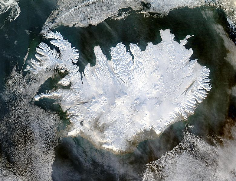
English: Iceland, from the NASA Visible Earth image gallery. More info below
Deutsch: Satellitenbild Islands aus der NASA-Fotogallerie Visible Earth. Mehr Information untenstehend auf Englisch.
Українська: Супутниковий знімок Ісландії, 29 січня 2004 року.
datum 29. januara 2004
žórło http://veimages.gsfc.nasa.gov/6605/Iceland.A2004028.1355.250m.jpg
awtor Jeff Schmaltz
dowolnosć
(dalewužiwanje tuteje dataje)
Public domain Diese Datei ist gemeinfrei (public domain), da sie von der NASA erstellt worden ist. Die NASA-Urheberrechtsrichtlinie besagt, dass „NASA-Material nicht durch Urheberrecht geschützt ist, wenn es nicht anders angegeben ist“. (NASA-Urheberrechtsrichtlinie-Seite oder JPL Image Use Policy).
Warnung:

Picture info

  • Description and alternative versions http://visibleearth.nasa.gov/view_rec.php?id=6605
  • Metadata: Sensor Aqua/MODIS
  • Visualization Date: 2004-01-29
  • Credit: Jeff Schmaltz, MODIS Rapid Response Team, NASA/GSFC
  • Description: Iceland lives up to its name in this image, acquired by the Moderate Resolution Imaging Spectroradiometer (MODIS) on NASA's Terra satellite on January 28, 2004. The island country is completely covered in white snow and ice, obscuring the permanent glaciers and icecaps that exist year-round. The effect of ice on this island sandwiched between the North Atlantic and the Greenland Sea, just below the Arctic Circle, is visible along its rugged northern shores. Over millennia, ice has carved out deep fjords leaving fringes of land that extend like fingers into the ocean.
  • Source: ”The purpose of NASA's Earth Observatory is to provide a freely-accessible publication on the Internet where the public can obtain new satellite imagery and scientific information about our home planet. The focus is on Earth's climate and environmental change. In particular, we hope our site is useful to public media and educators. Any and all materials published on the Earth Observatory are freely available for re-publication or re-use, except where copyright is indicated. We ask that NASA's Earth Observatory be given credit for its original materials.”

Krótkowopisy

Dodaj jednolinkowy wopis tuteje dataje.

W tutej dataji zwobraznjene objekty

motiw

Wersije dataje

Klikń na wěsty čas, zo by wersiju dataje w tutym času zwobraznił.

ČasWobrazowy napohladRozeznaćeWužiwarKomentar
aktualnje5. decembra 2004, 07:49Wobrazowy napohlad za wersiju wot 5. decembra 2004, 07:492.600x2.000 (869 kB)Ævar Arnfjörð Bjarmasonbigger version
6. nowembra 2004, 14:06Wobrazowy napohlad za wersiju wot 6. nowembra 2004, 14:06540x405 (68 kB)RanveigNASA satelite image of Iceland

Dataja so na slědowacych stronach wužiwa:

Globalne wužiwanje dataje

Slědowace druhe wikije wužiwaja tutón wobraz:

Globalne wužiwanje tuteje dataje pokazać

Metadaty

Z Wikipedije, swobodneje encyklopedije