Dataja:Grossglockner from SW.jpg

Wulkosć tutoho přehlada: 800 × 600 pikselow. Druhe rozeznaća: 320 × 240 pikselow | 640 × 480 pikselow | 1.024 × 768 pikselow | 1.280 × 960 pikselow | 1.884 × 1.413 pikselow.
Wersija z wyšim rozeznaćom (1.884 × 1.413 pikselow, wulkosć dataje: 421 kB, typ MIME: image/jpeg)
Zjeće
| wopis |
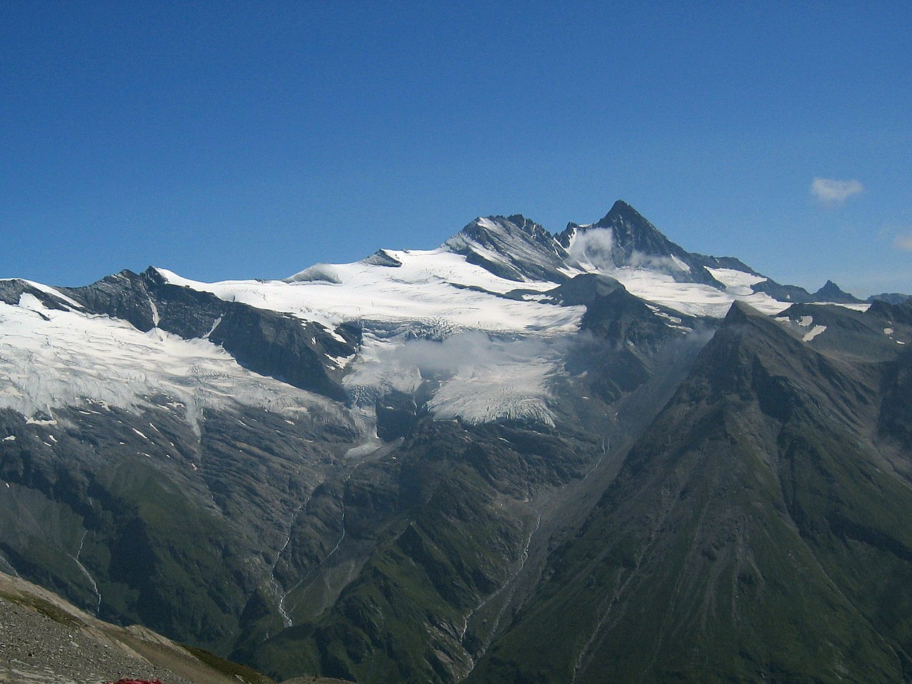
Deutsch: Großglockner vom Südwesten. Der Großglockner (3.797 m) ist der höchste pyramidenförmig erscheinende Gipfel rechts von der Mitte. Der breite großteils schneefreie Berg links davon ist die Glocknerwand (3.722 m) und ihr linker Eckpfeiler Hofmannspitze. Links im Bild ist über einer Felswand (Romariswand) der Romariswandkopf (3.511 m) zu sehen. Der pyramidenförmige Berg im Vordergrund, vor dem Großglockner, ist die Zollspitze (3.024 m).
Der Gletscher vor dem Großglockner ist das Teischnitzkees; rechts oberhalb der Romariswand ist das Fruschnitzkees. Aufnahmeort: Am Silesia Höhenweg, nahe dem Sattel nördlich des Gradötzkogel aufgenommen, in ca. 2.800 m Höhe und in 8 km Entfernung vom Gipfel des Großglockners.English: Großglockner seen from the southwest. The Großglockner (3.797 m), the highest peak of Austria, is the highest peak in the image, pyramid-shaped, right of the center. Left of it, the more elongated and mostly snow-free mountain is the Glocknerwand (3.722 m) with its left pillar Hofmannspitze. The Romariswandkopf (3.511 m) is the peak of the rock wall (Romariswand) in the left part of the image. The pyramid-shaped peak in front of the Großglockner is the Zollspitze (3.024 m). The glacier in front of the Großglockner is the Teischnitzkees, that behind and right of the Romariswand is the Fruschnitzkees. Français : Le Grossglockner vu du sud-ouest. Le Grossglockner (3797 m), est le plus haut sommet d'Autriche. La montage plus allongée et presque libre de neige à sa gauche porte le Glocknerwand (3722 m) et le Hofmannspitze. Tout à gauche, le Romariswandkopf ("Pic du mur de pierre", 3511 m) est visible. Le sommet en forme de pyramide devant le Grossglockner s'appelle Zollspitze (3024 m). Le glacier visible devant le Grossglockner est le Teischnitzkees, celui se trouvant en arrière et à droite du Romariswand, le Fruschnitzkees. |
| datum | |
| žórło | Photo taken by myself, cropped, color balance slightly adjusted. |
| awtor | Michael Schmid |
| druhe wersije tuteje dataje |

Licencowanje
Ja, awtor tutoho dźěła, wozjewjam je z tym pod slědowacej licencu:
Diese Datei ist unter der Creative-Commons-Lizenz „Namensnennung – Weitergabe unter gleichen Bedingungen 2.0 Österreich“ lizenziert.
- Směš:
- zhromadnje wužiwać – dźěło kopěrować, rozšěrić a dale dać
- změšeć – zo by dźěło přiměrił
- Pod slědowacymi wuměnjenjemi:
- připokazanje – Dyrbiš informacije wo awtorstwje podać, wotkaz k icency přidać a podać, kotre změny sće přewjedł. Móžeće to na přihódne wašnje činić, ale nic tak, zo zaćišć nastawa, zo licencudawar was abo waše wužiwanje podpěruje.
- dźělić – Jeli tute dźěło měnješ, přetworjuješ abo na njo natwarješ, móžeš hotowe dźěło jenož pod samsnej abo podobnej licencu kaž tuta rozšěrić.

Dieses Bild wurde unter Berücksichtigung der Leitlinie für Qualitätsbilder bewertet und gilt als Qualitätsbild.
|
Wersije dataje
Klikń na wěsty čas, zo by wersiju dataje w tutym času zwobraznił.
| Čas | Wobrazowy napohlad | Rozeznaće | Wužiwar | Komentar | |
|---|---|---|---|---|---|
| aktualnje | 10. julija 2005, 20:04 | | 1.884x1.413 (421 kB) | Schmid | {{Information |Description = Großglockner seen from the southwest | Source = Photo taken by myself, cropped, color balance slightly adjusted. | Date = 2003-Jul-30 | Author = Michael Schmid | Permission = Michael Schmid put |
Datajowe wužiwanje
Dataja so na slědowacych stronach wužiwa:
Globalne wužiwanje dataje
Slědowace druhe wikije wužiwaja tutón wobraz:
- Wužiwanje na an.wikipedia.org
- Wužiwanje na ar.wikipedia.org
- Wužiwanje na bg.wikipedia.org
- Wužiwanje na bn.wikipedia.org
- Wužiwanje na bn.wikibooks.org
- Wužiwanje na bs.wikipedia.org
- Wužiwanje na ca.wikipedia.org
- Wužiwanje na cs.wikipedia.org
- Rakousko
- Großglockner
- Karavanky
- Totes Gebirge
- Ennstalské Alpy
- Vysoké Taury
- Nízké Taury
- Hory Solné komory
- Dachstein
- Rakouské Alpy
- Zillertalské Alpy
- Ötztalské Alpy
- Stubaiské Alpy
- Gailtalské Alpy
- Steinberge
- Hochschwab
- Rax
- Berchtesgadenské Alpy
- Vídeňský les
- Gutensteinské Alpy
- Türnitzské Alpy
- Mürzstegské Alpy
- Ybbstalské Alpy
- Hornorakouské předhůří
- Tennengebirge
- Dientener Berge
- Kaisergebirge
- Chiemgauské Alpy
- Rofan
- Karwendel
- Nockberge
- Wetterstein
- Lechtalské Alpy
- Verwall
- Lechquellengebirge
- Bregenzský les (pohoří)
- Algavské Alpy
- Lavanttalské Alpy
- Villgratenské hory
- Kitzbühelské Alpy
- Tuxské Alpy
- Silvretta
Globalne wužiwanje tuteje dataje pokazać