Dataja:Zugspitze Airview 01.jpg

Wersija z wyšim rozeznaćom (2.814 × 2.111 pikselow, wulkosć dataje: 4,12 MB, typ MIME: image/jpeg)
Zjeće
| wopis |
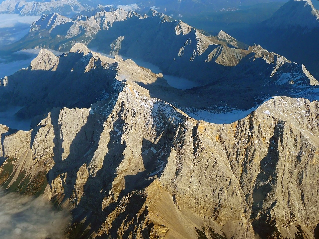
English: The "Zugspitze", the highest mountain in Germany as seen from an aircraft. View from West, with mountains in Wetterstein around and valley Reintal with fog or clouds from above.
Deutsch: Die "Zugspitze", der höchste Berg Deutschlands aus einem Flugzeug gesehen. Der Hauptgipfel des Wettersteingebirges ist umgeben von tieferliegenden Graten wie dem Jubiläumsgrat, dem Schneefernerkopf rechts neben dem Gipfel in der Mitte, mit dem Zugspitzplatt und dem steil abfallenden Reintal dahinter, die beide bereits im Schatten des späten Nachmittags liegen. Oktober mit Sonne auf dem Gipfel. |
| datum | |
| žórło | Swójske dźěło |
| awtor | Africaspotter |
| Pozicija kamery | | Tónle a dalše wobrazy pola: OpenStreetMap |
|---|
Licencowanje
- Směš:
- zhromadnje wužiwać – dźěło kopěrować, rozšěrić a dale dać
- změšeć – zo by dźěło přiměrił
- Pod slědowacymi wuměnjenjemi:
- připokazanje – Dyrbiš informacije wo awtorstwje podać, wotkaz k icency přidać a podać, kotre změny sće přewjedł. Móžeće to na přihódne wašnje činić, ale nic tak, zo zaćišć nastawa, zo licencudawar was abo waše wužiwanje podpěruje.
- dźělić – Jeli tute dźěło měnješ, přetworjuješ abo na njo natwarješ, móžeš hotowe dźěło jenož pod samsnej abo podobnej licencu kaž tuta rozšěrić.
1. Online-Medien:
2. Print-Medien:
Ich bitte um Zusendung eines Belegexemplares bzw. der URL, wo das Foto benutzt wird. Bitte schreiben Sie eine E-Mail, wenn Sie meine Adresse für die Zusendung eines Belegexemplares benötigen oder weitergehende Fragen zur Lizenznutzung haben. Eine Auswahl meiner Fotos finden Sie auch auf www.felixgottwald.net. |
1. Online media:
2. Print media:
Please send me a specimen copy or the URL of the website where the image is used. Please write an email, if you need my postal address for sending a specimen copy or have further questions regarding the terms of licence. You may also find a selection of my photos at www.felixgottwald.net. |
| Annotations | This image is annotated: View the annotations at Commons |
Wersije dataje
Klikń na wěsty čas, zo by wersiju dataje w tutym času zwobraznił.
| Čas | Wobrazowy napohlad | Rozeznaće | Wužiwar | Komentar | |
|---|---|---|---|---|---|
| aktualnje | 13. oktobra 2010, 21:00 | | 2.814x2.111 (4,12 MB) | Africaspotter | {{Information |Description={{en|1=The "Zugspitze", the highest mountain in Germany as seen from an aircraft.}} {{de|1=Die "Zugspitze", der höchste Berg Deutschlands aus einem Flugzeug gesehen.}} |Source={{own}} |Author=[[User:Africaspotter|Africaspotter] |
Datajowe wužiwanje
Dataja so na slědowacych stronach wužiwa:
Globalne wužiwanje dataje
Slědowace druhe wikije wužiwaja tutón wobraz:
- Wužiwanje na be.wikipedia.org
- Wužiwanje na bg.wikipedia.org
- Wužiwanje na bs.wikipedia.org
- Wužiwanje na cs.wikipedia.org
- Wužiwanje na de.wikipedia.org
- Wužiwanje na dsb.wikipedia.org
- Wužiwanje na en.wikipedia.org
- Wužiwanje na eo.wikipedia.org
- Wužiwanje na et.wikipedia.org
- Wužiwanje na eu.wikipedia.org
- Wužiwanje na fi.wikipedia.org
- Wužiwanje na fr.wikipedia.org
- Wužiwanje na gl.wikipedia.org
- Wužiwanje na he.wikipedia.org
- Wužiwanje na hu.wikipedia.org
- Wužiwanje na id.wikipedia.org
- Wužiwanje na is.wikipedia.org
- Wužiwanje na it.wikipedia.org
- Wužiwanje na ja.wikipedia.org
- Wužiwanje na lt.wikipedia.org
- Wužiwanje na mr.wikipedia.org
- Wužiwanje na ms.wikipedia.org
- Wužiwanje na nl.wikipedia.org
- Wužiwanje na no.wikipedia.org
- Wužiwanje na pl.wikipedia.org
- Wužiwanje na pnb.wikipedia.org
- Wužiwanje na pt.wikipedia.org
- Wužiwanje na ro.wikipedia.org
- Wužiwanje na simple.wikipedia.org
- Wužiwanje na sk.wikipedia.org
- Wužiwanje na sv.wikipedia.org
- Wužiwanje na tr.wikipedia.org
- Wužiwanje na uk.wikipedia.org
- Wužiwanje na vi.wikipedia.org
- Wužiwanje na zh.wikipedia.org