Dataja:Isle of Angleseymap 1946.jpg

Wulkosć tutoho přehlada: 737 × 600 pikselow. Druhe rozeznaća: 295 × 240 pikselow | 590 × 480 pikselow | 944 × 768 pikselow | 1.259 × 1.024 pikselow | 2.517 × 2.048 pikselow | 4.747 × 3.862 pikselow.
Wersija z wyšim rozeznaćom (4.747 × 3.862 pikselow, wulkosć dataje: 4,73 MB, typ MIME: image/jpeg)
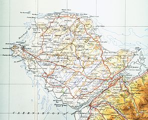
| wopis | Map of Isle of Anglesey from 1946. Scale 0.25 inch to the mile 600DPI Sheet 4 "north wales and manchester" fourth edition |
| datum | |
| žórło | OS Sheet 4 "north wales and manchester" fourth edition |
| awtor | OS |
This work is an Ordnance Survey map over 50 years old, which is covered by Crown Copyright which in this case expires 50 years after publication. Ordnance Survey does however ask that they be credited and that the date of publication be given.
Any ancillary rights gained through the creation of the electronic version are granted as freely usable under any circumstances.
|
Dieses von der Regierung des Vereinigten Königreichs erstellte Werk ist gemeinfrei.
Dies liegt daran, dass es entweder:
Weitere Informationen. Siehe auch Urheberrecht and Kunstwerke unter dem Crown copyright (PDF).
|
 |
Wersije dataje
Klikń na wěsty čas, zo by wersiju dataje w tutym času zwobraznił.
| Čas | Wobrazowy napohlad | Rozeznaće | Wužiwar | Komentar | |
|---|---|---|---|---|---|
| aktualnje | 17. nowembra 2009, 18:10 | | 4.747x3.862 (4,73 MB) | Lirion | slight colour improvements |
| 9. meje 2009, 21:11 |  | 4.747x3.862 (4,28 MB) | Geni | {{Information |Description=Map of Isle of Anglesey from 1946. Scale 0.25 inch to the mile 600DPI Sheet 4 "north wales and manchester" fourth edition |Source=OS Sheet 4 "north wales and manchester" fourth edition |Date=1954 |Author=OS |Permission=none need |
Datajowe wužiwanje
Dataja so na slědowacych stronach wužiwa:
Globalne wužiwanje dataje
Slědowace druhe wikije wužiwaja tutón wobraz:
- Wužiwanje na cy.wikipedia.org
- Wužiwanje na de.wikipedia.org
- Wužiwanje na es.wikipedia.org
- Wužiwanje na hu.wikipedia.org
- Wužiwanje na ru.wikipedia.org
- Wužiwanje na sv.wikipedia.org