Dataja:LA County Incorporated Areas.svg

Größe der PNG-Vorschau dieser SVG-Datei: 730 × 599 pikselow. Druhe rozeznaća: 292 × 240 pikselow | 585 × 480 pikselow | 935 × 768 pikselow | 1.247 × 1.024 pikselow | 2.494 × 2.048 pikselow | 950 × 780 pikselow.
Wersija z wyšim rozeznaćom (SVG-dataja, zakładna wulkosć: 950 × 780 pikselow, datajowa wulkosć: 261 kB)
Zjeće
| wopis |
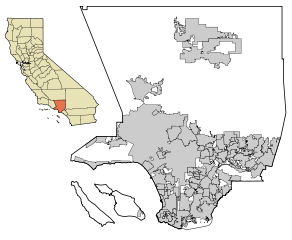
This map shows all the incorporated areas (cities) within Los Angeles County, in Southern California. I created it in Inkscape using data from the Los Angeles County Website (Los Angeles County Incorporated Area and District Map (PDF). |
| datum | |
| žórło | My own work, based on public domain information. Though I strove to be as accurate in the detail as possible, the information shown is not guaranteed to be completely accurate. |
| awtor | Ixnayonthetimmay |
| dowolnosć (dalewužiwanje tuteje dataje) |
Public Domain |
| druhe wersije tuteje dataje | See Category:Maps of Los Angeles County, California for other versions of this image. |
Licencowanje
| Ich, der Urheberrechtsinhaber dieses Werkes, veröffentliche es als gemeinfrei. Dies gilt weltweit. W někotrych krajach je to snano prawnisce njemóžno; jeli tomu tak je: Ich gewähre jedem das bedingungslose Recht, dieses Werk für jedweden Zweck zu nutzen, es sei denn, Bedingungen sind gesetzlich erforderlich. |
Wersije dataje
Klikń na wěsty čas, zo by wersiju dataje w tutym času zwobraznił.
| Čas | Wobrazowy napohlad | Rozeznaće | Wužiwar | Komentar | |
|---|---|---|---|---|---|
| aktualnje | 18. junija 2007, 00:36 | | 950x780 (261 kB) | Ixnayonthetimmay | == Summary == {{Information |Description=This map shows the incorporated areas in Los Angeles County, California. I created it in Inkscape using data from the L |
Datajowe wužiwanje
Dataja so na slědowacych stronach wužiwa:
Globalne wužiwanje dataje
Slědowace druhe wikije wužiwaja tutón wobraz:
- Wužiwanje na az.wikipedia.org
- Wužiwanje na en.wikipedia.org
- Wužiwanje na eo.wikipedia.org
- Wužiwanje na es.wikipedia.org
- Wužiwanje na et.wikipedia.org
- Wužiwanje na fa.wikipedia.org
- Wužiwanje na fr.wikipedia.org
- Wužiwanje na he.wikipedia.org
- Wužiwanje na id.wikipedia.org
- Wužiwanje na lv.wikipedia.org
- Wužiwanje na nl.wikipedia.org
- Wužiwanje na pam.wikipedia.org
- Wužiwanje na pt.wikipedia.org
- Wužiwanje na ru.wikipedia.org
- Wužiwanje na tr.wikipedia.org
- Wužiwanje na vi.wikipedia.org